Layer mapping
ezu translate lowers a MapLibre GL style into an ezu recipe. This page is the
mapping table. For the workflow, see
from a MapLibre style; for what is approximated or
skipped, gaps and differences.
How close does it land?
Section titled “How close does it land?”Every pair below is one XYZ tile of protomaps-light —
68 layers, 11 of them symbol — converted with
ezu translate and rendered by ezu on the CPU, next to the same tile drawn by
maplibre-gl-js on a GPU (headless Chromium, software WebGL). Nothing is
hand-tuned between them: same style, same data, same tile.
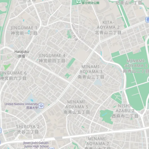
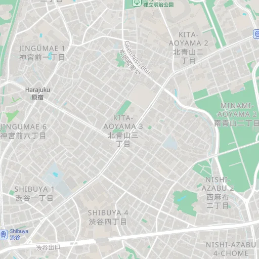
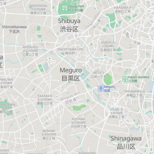
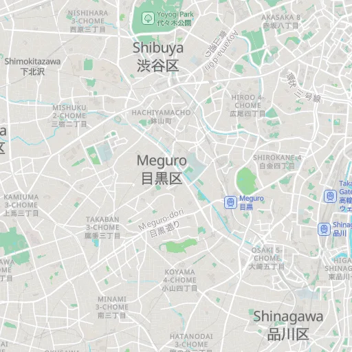
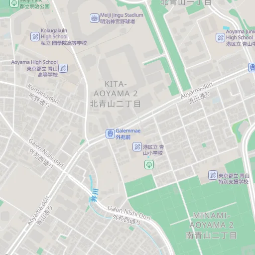
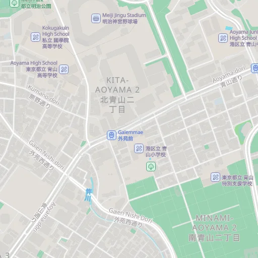
SSIM is structural similarity over 8×8 luma windows, which is less dominated by
antialiasing and label noise than a plain pixel difference. Reproduce any of these
with ezu-compare:
cargo run --release -p ezu-compare -- \ --style https://papers.reearth.land/styles/protomaps-light/style.json \ --tiles 14/14550/6452,12/3637/1613,15/29101/12904 \ --out out/compareTwo structural facts first:
- The ordered layer list becomes a
blendchain — painter’s algorithm written as a graph. - The recipe is zoom-independent. Zoom and data functions are emitted as raw
expressions on
*-exprfields and evaluated per tile, so one recipe renders correctly at every zoom.
Layer types
Section titled “Layer types”| MapLibre | ezu |
|---|---|
background |
solid |
fill (solid colour, fill-outline-color) |
features + fill-solid (outline → edge) |
line (+ line-dasharray, line-cap/join, line-gap-width) |
features → boundary (clip-edges: drop) → crisp stroke, dash in px. On a polygon source-layer the rings are stroked without the tile-buffer clip edges, as MapLibre does. A gap renders MapLibre’s casing annulus — one stroke’s footprint with the corridor knocked out — so joins, caps and dash phase behave like the GL shader |
circle (+ circle-stroke-*) |
a circle sprite stamped at each point; the stroke is a larger ring stamped underneath |
raster |
raster |
hillshade (over raster-dem) |
dem + hillshade (tone calibration still approximate). The source encoding maps mapbox (the default) to mapbox-rgb and terrarium to terrarium; a custom encoding is accepted only when its factors equal one of those two, otherwise it warns and is read as mapbox-rgb |
heatmap |
features → density (GL-JS kernel) → color-ramp, with the colour expression over heatmap-density baked to a 256-entry ramp per tile |
fill-extrusion |
flat footprint fill-solid using fill-extrusion-color — no 3-D, height and base dropped |
symbol (icons) |
the icon rides the layer’s label: a point symbol’s icon and text boxes join the shared collision index and place or drop as one unit |
symbol (text) |
text node, point or line placement |
Symbol detail
Section titled “Symbol detail”Icons. icon-image (including data-driven), icon-size/-rotate/-opacity/
-anchor/-offset/-padding, icon-allow-overlap/icon-overlap/
-ignore-placement, icon-optional/text-optional, and icon-text-fit +
-padding with nine-slice stretchX/stretchY/content metadata all convert.
Icon-only symbol layers place too. Line-placed icons lower to a collision-free
stamp.
Text. symbol-placement: point / line / line-center with text-field,
-size/-color/-halo-*/-opacity, anchor, offset, justify, wrapping,
transform, spacing, a data-driven text-anchor on point placement (lowered to
anchor-expr), text-variable-anchor (with text-radial-offset and
per-anchor offset mirroring) and text-variable-anchor-offset, both lowered to
anchor-offsets, and on lines symbol-spacing / text-max-angle /
text-keep-upright. Collision: text-allow-overlap/-ignore-placement/
-padding, text-overlap, symbol-sort-key.
Point placement labels each point, and each polygon once at its pole of
inaccessibility (MapLibre’s findPoleOfInaccessibility, per tile); line placement walks each polyline with
tangent-rotated glyphs and per-glyph collision, anchored on tile-clipped geometry
with MapLibre’s spacing phases.
All of a style’s symbol layers collide in one shared index. Each lowers to a
text-labels (candidates) + text-draw (placed labels) pair around a single
label-placement node, placed top layer first — so a POI can knock out a road
name, as MapLibre does. Placement is deterministic across tiles: candidates are
gathered from the eight neighbours, deduped, ordered by symbol-sort-key with ties
broken by tile feature order, and placed greedily.
Fonts. Zero-config: an unmapped text-font stack is served from the style’s own
glyphs endpoint as an SDF glyphs source — the same pre-rendered glyphs
MapLibre draws. --font "NAME=SOURCE" (or ConvertOptions::fonts) overrides with
a real font per entry for outline rendering. A {token} field is an expression
once the style is migrated (--migrate, see below).
Patterns and sprites
Section titled “Patterns and sprites”| MapLibre | ezu |
|---|---|
fill-pattern (constant) |
icon → tiling, clipped to the fill shape via blend { clip: true } |
line-pattern (constant) |
icon → line-stamp (over boundary, so polygon rings too), repeated along the line and fitted to line-width |
top-level sprite (single URL or [{id, url}]) |
one sprite source per sheet — atlas <url>.png plus index <url>.json, or an inline index. sheet:icon names supported |
Data, filters and functions
Section titled “Data, filters and functions”| MapLibre | ezu |
|---|---|
layer filter, expression form |
passes through verbatim as the features node’s filter-expr |
layer filter, legacy form (bare fields, !in, !has, none) |
converted by maplibre_expr::convert_legacy_filter — MapLibre’s own pre-compile conversion, strict-type semantics included |
zoom / data functions (interpolate, step, any expression) |
emitted raw onto the target node’s *-expr field, evaluated per tile |
legacy forms — {stops} function objects, {token} label strings, non-standard hsl() colours |
converted only with --migrate (ConvertOptions::migrate), by maplibre_expr::migrate — MapLibre’s own migrate, each value converted with its property spec. Off by default: a legacy form is passed through untouched and named in a warning; a function object is then rejected by ezu-paint, a token string renders literally |
layer minzoom / maxzoom |
the features node’s min-zoom / max-zoom render-time gate |
multiple vector sources |
all emitted, each with its minzoom / maxzoom as min-zoom / max-zoom; each features node targets its (source, layer) |
inline / remote geojson source |
a geojson source; the host projects it per tile and binds one layer (features targets (source, source)) |
CSS named colours (steelblue, transparent, …) |
resolved to hex |
layout.visibility: "none" |
dropped by default, or kept behind a switch with --keep-hidden (flip select to b to enable) |
Measuring your own style
Section titled “Measuring your own style”The figures at the top of this page were produced by ezu-compare, which
converts a style, renders it with ezu, renders a maplibre-gl-js reference, and
reports RMSE, “visibly different” pixel fraction, and SSIM per tile. Point it at
your style rather than trusting a general claim:
cargo run --release -p ezu-compare -- \ --style YOUR_STYLE_URL_OR_PATH \ --tiles 12/3637/1613,13/7275/3225,14/14550/6452 \ --out out/compareIt writes the ezu render, the reference, a diff image, and the emitted recipe, so a disagreement is something you can look at rather than infer.
Map renders on this site are made fromOpenStreetMap data viaProtomaps (© OpenStreetMap contributors), elevation from Re:Earth Terrain,Mapterhorn andEGM2008 (NGA), and aerial imagery from GSI Japan(© 国土地理院). The painterly styles use CC0 brushes byDavid Revoy.